

What she actually did
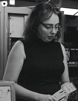
Working from sounding profiles collected aboard ships she was not allowed to board, Tharp plotted six west-to-east cross-sections of the North Atlantic in 1952 and found something nobody had seen: a continuous V-shaped notch running down the middle of the Mid-Atlantic Ridge. A rift valley. If the seafloor was splitting apart along a seam that ran the length of an ocean, then continental drift — then a fringe theory, bordering on heresy — had a mechanism. Her maps, produced with Bruce Heezen and painted by Heinrich Berann, were the first scientific picture of the ocean floor and the visual evidence that converted a generation to plate tectonics.
Why you have never heard of her
Heezen's first response to her discovery was to dismiss it as "girl talk". It took her a year to convince him, and he only accepted it when an independent map of earthquake epicentres landed exactly on her rift. Women were barred from the research vessels, so for the first eighteen years of the collaboration Heezen gathered the data at sea and Tharp interpreted it on land — an arrangement that made him the field scientist and her the draughtswoman. In 1964 the Lamont director fired her outright during a feud with Heezen; she carried on working from home. Her name was left off key publications for years.
Her life
Tharp's father was a soil surveyor for the US Department of Agriculture, and she went out on surveys with him as a child. She attended more than twenty schools by the time she finished high school.
She got into science through a wartime side door. With men away at war, the University of Michigan opened its geology master's programme to women to fill petroleum industry jobs; Tharp took the degree, plus a second one in mathematics from Tulsa. In 1948 she arrived at Columbia's Lamont Geological Observatory, where she was the first woman hired, and was set to drafting.
What she did with the drafting job was not drafting. She converted echo-sounding profiles into physiographic diagrams — sketched-perspective landscapes rather than contour lines, partly because contour maps of the seafloor were classified for their submarine value. The result was that for the first time, people could look at the bottom of the ocean and see mountains.
She finally went to sea in 1968, on the USNS Kane. She and Heezen published the World Ocean Floor panorama in 1977, the year he died at sea in a submersible off Iceland. Tharp worked another three decades, and the Library of Congress named her one of the four greatest cartographers of the twentieth century in 1997.
“I was so busy making maps I let them argue. I figured I'd show them a picture of where the rift valley was and where it pulled apart.”— Marie Tharp
Things worth knowing
- "Girl talk"Heezen's verdict on the rift valley. He preferred the Expanding Earth hypothesis. The earthquake map changed his mind, not her argument.
- Barred from the ships for eighteen yearsShe mapped an ocean she was not permitted to sail on until 1968.
- She drew it because contour maps were classifiedDetailed seafloor contours had military value, so she invented a sketched physiographic style instead — which turned out to be far more legible to non-specialists.
- Jacques Cousteau tried to disprove herHe towed a camera across the Mid-Atlantic Ridge expecting to show there was no rift. The film showed the rift.
- One of the century's four great cartographersThe Library of Congress said so in 1997, placing her alongside Ptolemy.
Timeline
Takes a geology master's at Michigan, through a programme opened to women because of the war.
Joins Lamont Geological Observatory as its first woman scientist, assigned to drafting.
Plots six Atlantic profiles and identifies a continuous rift valley along the Mid-Atlantic Ridge.
Heezen dismisses the finding as "girl talk"; it takes a year and an earthquake map to convince him.
Publishes the first physiographic map of the North Atlantic floor with Heezen.
Fired by the Lamont director in a dispute with Heezen; continues working from home.
Finally allowed to go to sea, aboard the USNS Kane.
The World Ocean Floor map is published, the year Heezen dies.
What it means now
Plate tectonics is the organising theory of the earth sciences, and the single image that persuaded most people of it was drawn by a woman who was not allowed on the boat. Google Earth's ocean layer descends directly from her maps. She described the work as "a once-in-a-lifetime — a once-in-the-history-of-the-world — opportunity for anyone, but especially for a woman in the 1940s."
